
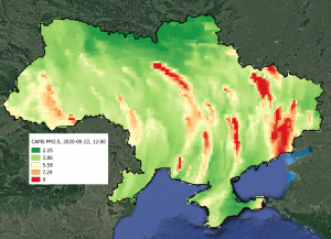
Every day we are more and more concerned about the environment and, given its condition, the issue of air quality monitoring is becoming increasingly important and needs more attention and research. Among the many projects in this field, the leading place is occupied by the staff of the Institute of Space Research of NASU and SCAU, Institute of Physics and Technology and Chairman of the PAEU Ecomonitoring Committee Oleksandr Karpenko in the project of the National Research Fund of Ukraine SMURBS (SMart URBan Solutions) program Horizon-2020 ERA-Planet within which the methodology of obtaining a city atlas similar to the European one and a pollution map by quarters of Kyiv became known.
This is the fact that Ukraine does not have sufficient resources to fully implement global air quality control yet, for example, within the CAMS (Copernicus Atmosphere Monitoring Service). But it is obviously not an obstacle to presenting solutions for environmental managers Ecobusiness group own solutions to improve monitoring air quality in Ukraine.
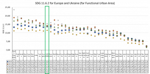
One of the main tasks of the project in question is to improve the methodology of air quality monitoring developed in the SMURBS project for the cities of Ukraine. So far, for the first time, the Sustainable Development Goal (SDG) indicator 11.6.2 “Annual Mean Levels of Fine Particulate Matter (PM2.5) in Urban Areas” for Ukraine has been assessed. The SDG indicator 11.6.2 has a clear calculation methodology that is uniform for European countries. The only difference between the methodology for calculating indicator 11.6.2 in different countries is the input data, which differ in spatial resolution, refresh rate, etc. The mentioned indicator is evaluated annually at the country level.
If we talk about the Copernicus Atmosphere Monitoring Service which provides information on air quality assessment in the form of near-real-time analysis of the weather forecast for Europe including Ukraine, the service provides data on a wide range of pollutants, including PM2. 5, which was selected as the main indicator for research within the project of the National Research Fund of Ukraine.
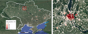
There is no defined concept of FMZ for the territory of Ukraine which is necessary for the SDG 11.6.2 indicator assessment, so one of the project goals is to propose the concept and methodology of FMZ calculating for Ukraine.
In this case, we are able to use some global products that are being built around the world, e.g. data on the population of GHSL and NASA.
Therefore, analyzing the overall results, we can see that there was a significant decrease in 2017 in the indicator responsible for improving air quality in the country as a whole. It can also be noted that the 11.6.2 indicator does not changes much at the level of the whole country depending on the provider of information about the population. This confirms the possibility of using global population data to calculate this SDG indicator.

It became known that all European countries had better air quality in 2017 rather than in other years. The following figure shows the results of the evaluation of 11.6.2 indicators for Ukraine for 5 years in comparison with European countries, which calculate this indicator centrally.
The considered air quality monitoring methodologies are just beginning to be adapted and applied for the territory of Ukraine, however, in general, Ukraine has a problem related with non-developed and non-harmonized with Europe legislation and the corresponding decision-making. In particular, creation of such harmonized products, their implementation and active use should be the first steps to make Ukraine closer to European countries.
The Ministry of Environmental Protection and Natural Resources of Ukraine is already launching the first measures to implement European air quality monitoring practices in Ukraine, which should result in a full-fledged air quality monitoring service in Ukraine.
In conclusion it should be noticed that there are still many open questions and interesting researches in the «Geospatial models and information technologies of satellite monitoring of smart city problems» project, about which we will write further.